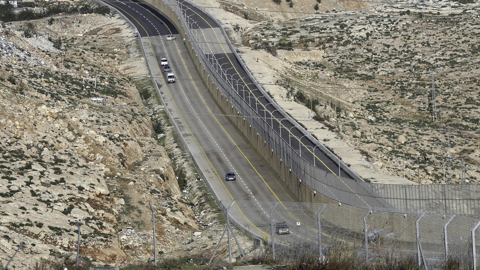
Israel opened a new road in the central occupied West Bank on Thursday with an eight-meter wall separating Palestinian and Israeli traffic, leading many to deem the route “Apartheid Road.”
The road connects the illegal Geva Binyamin Settlement, southeast of Ramallah, to Route 1, a major highway that runs through the West Bank and into Israeli-occupied East Jerusalem.
The new 5-kilometer Route 4370, also known as the “Easter Ring Route” is a four lane route: two lanes for Israeli settlers travelling from the West Bank into Jerusalem, and two lanes circumventing around the borders of Jerusalem for Palestinians with West Bank IDs.
The Israeli-accessible portion of the road is currently only operating between 5am and noon, but will be fully opened as of January 10th, Israeli media reported.
While Israeli media have reported that Palestinians with Jerusalem IDs or Israeli citizenship would be allowed to use the Israeli-side of the road to travel from Jerusalem to the West Bank, heightened security and a new checkpoint along the road have led to speculation that Palestinians, no matter what ID they carry, will be subject to discrimination by Israeli border police who man the checkpoint.
There are dozens of segregated and settler-only roads across the occupied Palestinian territory, but Route 4370 is the first of its kind to have a wall — half concrete, half fence — separating Palestinians from Israelis.
Israeli authorities have said the road is meant to ease traffic congestion at the Hizma checkpoint north of Jerusalem, and have even claimed the road offers “a solution for all populations, Israeli and Palestinian.”
Israel’s Public Security Minister called he road “an example of the ability to create a shared life between Israelis and Palestinians, while dealing with the existing security challenges.”
Palestinian officials and activists on the other hand have condemned the road as an example of Israeli apartheid and racism against Palestinians.
The Palestinian Foreign Ministry slammed the new road as “emphasizing Israel’s approach aiming to undermine prospects for geographical and demographic contiguity of the West Bank.”
The Times of Israel quoted PA Transportation Ministry Spokesman Mohammad Hamdan as saying that “all roads in the State of Palestine should be accessible to Palestinians. This new road is absolutely unacceptable and embodies barefaced discrimination against the Palestinian people.”
BOOK AD
Coup d’etat in Slowmotion
by Ole Dammegard
For almost 30 years investigator Ole Dammegård has been on a quest to find the truth behind some of the worst conspiracies in the history of world – such as the murders US President John F. Kennedy, Robert Kennedy, John Lennon and the blowing up of m/s Estonia killing at least 852 innocent people. This has taken him on a very frightening and dangerous journey into unknown territories. What has been claimed as acts by lone madmen has turned out to be connected to the International military industrial complex and top level high finance, all sanctioned locally behind dark smoke screens. This ground breaking book focuses on the assassination of the Swedish Prime Minister Olof Palme, who was gunned down in February 1986. In Volume I secret agents, mercenaries, professional assassins, top politicians and innocent scapegoats fill the pages of this explosive book which shows a side of Sweden and the western world earlier glimpsed by very few. This is not the private opinion of one individual, but the disclosure of a puzzle so vast that it blows your mind. Let the detailed content speak for itself, but do not accept it uncritically. Read it – make up your own mind – then spread it.
Years in the making
The ‘Apartheid Road’ has been years in the making, and according to rights groups, and is about much more than just easing traffic for settlers traveling to Jerusalem.
The road is a key infrastructural part of implementing Israel’s ‘Greater Jerusalem’ or ‘E1’ plan, which seeks the de facto annexation of the three settlement blocs adjacent to Jerusalem city – Gush Etzion to the South, Ma’ale Adumim/E-1 to the east and Givat Ze’ev to the north.
If implemented, the southern West Bank would be completely cut off from the north, making a future contiguous Palestinian state nearly impossible. It would essentially see the Israeli municipal boundaries of Jerusalem extend to the boundaries of Jericho.
Palestinian cartographer Khalil al-Tafakji warned Palestinian media outlets that opening the new road serves as a “prelude to displacing Palestinians from the area and starting settlement construction in the so-called E1 corridor”.
Israeli NGO Ir Amim said in a press release that the road was the “brainchild” of former Israeli Prime Minister Ariel Sharon, and was designed to “solve the dilemma of E-1 splitting the West Bank into northern and southern enclaves by using road infrastructure to preserve a semblance of contiguity between Ramallah and Bethlehem.”
By allowing Palestinians to still navigate between Ramallah and Bethlehem — in a very indirect manner — while diverting them from both the E-1 area and Jerusalem, the road eliminates a significant Palestinian presence.
Ir Amim says the opening of the road should be cause for “heightened vigilance,” and that while routing Palestinian traffic away from Jerusalem and E-1, the new road also “affords two key benefits for Israelis: 1) expediting traffic flow to Jerusalem for settlers from the Ramallah area and 2) enabling expansion of the settlement bloc around Ramallah.”
“While legislative initiatives like the Greater Jerusalem Bill and other plans designed to redraw the boundaries of the city may be stalled, infrastructure projects have already proven an effective tool for increasing connectivity between the blocs and the city, not only by solidifying physical linkages but also by eroding the boundaries of the city in the Israeli public consciousness,” the group said.


